Here we present some curious facts that you probably did not know and that, we are sure, you will remember on your next trip to this Treasure of the Mexican Pacific.
Fun facts about Riviera Nayarit: Did you know that…
1 The photography of Playa del Amor
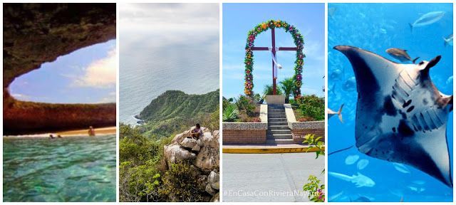
The photograph of the Love beach that gave Islas Marietas National Park worldwide fame, making it an icon of the Riviera Nayarit, was captured more than 7 years ago by Argentine photographer Nicolás Melani, who lives in Punta de Mita. Melani is dedicated to making tourist tours to the islands, so in one of these she was able to capture the image that has been an important factor in the tourism promotion of this destination worldwide.
“Many tourists from other countries arrive, mainly from Europe, asking about the place and referring to the photograph, since they consider (the Marietas) a landscape like no other. But the best thing is that it is in Nayarit and that it is real”, Melani has commented to various media.
This is the original photograph:

2 The Hill of the Monkey
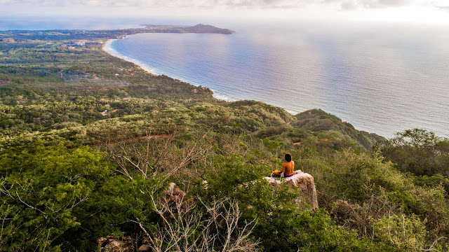
The Cerro del Mono is one of the many natural wonders of Riviera Nayarit, it is located north of the Bay of Banderas, in the vicinity of the Higuera Blanca community. In recent months this summit has gained popularity as a hiking route among residents and visitors of this tourist destination, but, Do you know the origin of its name?
There are several theories regarding this, based on the stories told by the inhabitants of Higuera Blanca, who have explored the Cerro del Mono for years. It is said that for the ancient Huichol natives this mountain was "sacred" and they would climb to the top from time to time to carry out their rituals, and as part of the ceremonies they placed several primate-shaped totems in the surroundings. Another version states that many years ago there were a large number of monkeys that inhabited the area, it is even still possible to see one or the other during hiking tours.
We suggest you write down the Cerro del Mono in the list of your next places to explore. You will fall in love with the spectacular 360° view from the top!
3 Sayulita, Magic Town of Nayarit
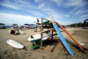
Known worldwide for the beauty of its ideal beaches for surfing and due to its bohemian atmosphere, it was originally called Santa Cruz Saloc according to the chronicler of Bahía de Banderas Eduardo Gómez Encarnación. In his chronicle “En los tiempos de…”, Gómez Encarnación refers that “In the Relación de Compostela, written by Lázaro Blanco in 1584, a town with the name of Santa Cruz Saloc appears on the coast of Valle de Banderas. Without a doubt, it is about Sayulita…”.
In 1798, on a map of the Coasts of Nueva Galicia —says the chronicler— the place continues to appear with the name of Santa Cruz. By then, it belonged to the Jaltemba Hacienda, owned by the Romero family from Guadalajara. It was Don Lauro González Guerra, originally from Sayula, Jalisco and administrator at that time of the Jaltemba Hacienda, who decided to baptize this small coastal hamlet located on the hacienda's land with the name of Sayulita, as a tribute to the native town that so much loved.
Did you imagine a name like that for Sayulita? Neither did we!

4 The Beach Cleaning Network
The Beach Cleaning Network (RLP) —the only one of its kind in a tourist destination— has been carrying out activities since June 2014, coordinated by the Riviera Nayarit Convention and Visitors Bureau (OVC) in conjunction with the Association of Hotels and Banderas Bay motels. Various groups of volunteers from different sectors of society participate in the RLP, such as NGOs, hotels, private companies, authorities and educational establishments, distributed in the coastal towns of the Riviera Nayarit, from Bucerías and Punta de Mita to Rincón de Guayabitos and the Mexcaltitan Island.
In 2019 alone, 45 cleanings were carried out that included beaches, streets, ravines, streams, river banks, vacant lots, ridges, etc., and a cleaning marathon that included locations in the municipality of Puerto Vallarta and Bahía de Banderas.
On your next visit to the Riviera Nayarit, would you like to join the cleanup activities? For more information, comments or if you are interested in learning more about the project, write to: [email protected]

5 The Cross of Huanacaxtle
Coastal town of the Riviera Nayarit, has a peculiar name. Many will believe that this is related to the religious celebration of May 3, marked by the Catholic Church as the feast of the Holy Cross, and although the people have adopted said feast as their own, the truth is that the true origin is not very clear. The best known reference is that the name comes from the cross that is found right at the entrance of the town, which was carved from a huanacaxtle tree. Another legend tells that a farmer on his way from Valle de Banderas to Punta de Mita found this beautiful spot facing the sea and rested there in the shade of a huanacaxtle tree. He liked the place so much that before leaving he would have decided to mark the trunk with a cross. His intention was to return one day, identify the tree that gave him shelter and establish his home there.
We don't know if he managed to return, but historical documents indicate that this typical fishing village was founded in 1930 by the Chávez family and the Blancas family.

6 Riviera Nayarit
It has several natural attractions with which it can be identified as a nature tourist destination, —among these the olive ridley turtle, the humpback whale, the bottle-mouth dolphin and Playa del Amor, to name a few—, however, one of its best kept secrets is a unique and wonderful species that sleeps at the bottom of the sea and that only occasionally surprises tourists sailing in the Bay with its flight: the Manta birostris, also known as the giant manta. Data from specialized biologists indicate that this singular creature reaches a size of up to 8.4 meters from tip to tip of its lateral fins, weighs around 1,400 kg and can live for more than 40 years. This species lacks a poisonous stinger on its tail, making it completely safe to swim alongside.
Write down on your wish list a tour of the Bay of Banderas, in one of those you come across this enigmatic specimen!

7 Six micro-destinations in the Riviera Nayarit
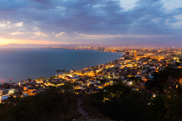
Six micro-destinations in the Riviera Nayarit —Nuevo Vallarta, Flamingos, Bucerías, La Cruz de Huanacaxtle, Destiladeras and Punta de Mita— are located around the Bay of Banderas, considered the largest natural bay in Mexico, with an extension of 42 kilometers; It is also the second largest in North America (the first place is occupied by Hudson Bay in Canada) and the seventh largest in the world. It is also one of the deepest bays in the world, with a depth of more than 900 meters.
Banderas Bay is located between the states of Jalisco and Nayarit. In the extreme south (Jalisco) is Cabo Corrientes, in the north (Nayarit) is Punta de Mita, and almost in the center is the mouth of the Ameca River, making a natural division between the two states. It should be noted that the city of Puerto Vallarta also shares this beautiful bay.
Now that you know a little more about Riviera Nayarit, you will surely keep it in mind when planning your next vacation.
- Huichol Handicrafts: The best and most beautiful in Mexico - 11 April 2023
- Compostela, Mexico's magical town that evokes Spain - 28 March 2023
- Nuevo Vallarta, where action and relaxation meet - 10 March 2023

